


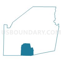
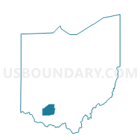
Voting District CONCORD, Highland County, Ohio
About
Outline

Summary
| Unique Area Identifier | 647920 |
| Name | Voting District CONCORD |
| County | Highland County |
| State | Ohio |
| Area (square miles) | 33.68 |
| Land Area (square miles) | 33.68 |
| Water Area (square miles) | 0.00 |
| % of Land Area | 100.00 |
| % of Water Area | 0.00 |
| Latitude of the Internal Point | 39.06031690 |
| Longtitude of the Internal Point | -83.64868010 |
Maps

Graphs
Select a template below for downloading or customizing gragh for Voting District CONCORD, Highland County, Ohio


Neighbors
Neighoring Voting District (by Name) Neighboring Voting District on the Map
- EAGLE TWP Voting District, Brown County, OH
- Voting District JACKSON, Highland County, OH
- Voting District NEW MARKET NW, Highland County, OH
- SEAMAN PRECINCT, Adams County, OH
- TRANQUILITY Voting District, Adams County, OH
- Voting District WASHINGTON, Highland County, OH
- Voting District WHITEOAK, Highland County, OH
- WINCHESTER TOWNSHIP Voting District, Adams County, OH
Top 10 Neighboring County Subdivision (by Population) Neighboring County Subdivision on the Map
- Winchester township, Adams County, OH (2,208)
- Scott township, Adams County, OH (2,180)
- New Market township, Highland County, OH (1,888)
- Concord township, Highland County, OH (1,415)
- Whiteoak township, Highland County, OH (1,371)
- Eagle township, Brown County, OH (1,344)
- Washington township, Highland County, OH (1,123)
- Jackson township, Highland County, OH (1,094)
Top 10 Neighboring Unified School District (by Population) Neighboring Unified School District on the Map
- Adams County/Ohio Valley Local School District, OH (24,029)
- Hillsboro City School District, OH (16,550)
- Eastern Local School District, OH (8,605)
- Bright Local School District, OH (4,960)
Top 10 Neighboring State Legislative District Lower Chamber (by Population) Neighboring State Legislative District Lower Chamber on the Map
- State House District 88, OH (122,323)
- State House District 89, OH (120,820)
- State House District 86, OH (114,338)
Top 10 Neighboring State Legislative District Upper Chamber (by Population) Neighboring State Legislative District Upper Chamber on the Map
Top 10 Neighboring 111th Congressional District (by Population) Neighboring 111th Congressional District on the Map
Top 10 Neighboring Census Tract (by Population) Neighboring Census Tract on the Map
- Census Tract 9551, Highland County, OH (6,298)
- Census Tract 9515, Brown County, OH (5,423)
- Census Tract 9552, Highland County, OH (4,865)
- Census Tract 7702, Adams County, OH (4,815)